About the Walk
Welcome to the Woldingham Heritage Walk, which was created in 2025 in a collaboration between Surrey County Council, Woldingham Parish Council, the Woldingham History Society, the Woldingham Association and the Woldingham Garden Village. Surrey County Council has funded the project via the Your Fund Surrey Small Community Projects Fund, and additional funding is being provided by Woldingham Parish Council.
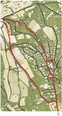
The walk is designed as a circular route, with nine heritage information boards placed at key locations:
- Woldingham Railway Station
- Church of St. Agatha
- North Downs Golf Club
- The Formation of Woldingham Village
- The Green
- The Crescent
- The Inchcape Memorial Church of St. Paul
- The Glebe
- Woldingham Garden Village
> Download Map, Route & Points of Interest
The Map, Route Instructions and Points of Interest along the walk are also repeated below.
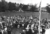
VE Day service on The Green, 1945
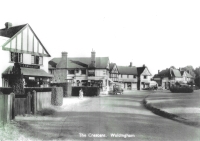
The Crescent circa 1958
Route Details
Start and end address: Woldingham Railway Station CR3 7LT
Difficulty: moderate terrain
Distance: 6.5km
Type of walk: circular
Approximate time: 1.75 hours
Accessibility: tarmac pavements, unmade roads, steps
Refreshments along the way:
> Woldingham Village Club
> The Dene at Knights Garden Centre
> North Downs Golf Club
Toilets: There are no public toilets along the route
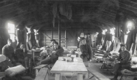
Soldiers living in one of the huts at Woldingham Camp 1915 (now The Garden Village)
Route Instructions
1. (2.0km; 2700 steps. Uphill, steep)
With the Station behind you turn R into Church Road. Continue up Church Road keeping the railway line on your R. At the top of the hill follow the L bend. Board 2 is on your R at St. Agatha’s Church.
2. (0.1km; 120 steps)
Continue to the end of Church Road. Turn R into Northdown Road to Board 3 opposite North Downs Golf Club.
3. (0.7km; 980 steps)
Go back past the end of Church Road and continue along Northdown Road to The Green. Boards 4 and 5 are next to the bench.
4. & 5. (0.2km; 270 steps)
Continue across The Green and onto Station Road. Safely cross over to The Village Hall. Continue to The Crescent, Board 6 is in the centre next to the noticeboards.
6. (0.3km; 350 steps)
Continue through The Crescent and onto Station Road, passing the tennis courts on your R. Turn R into Croft Road. Board 7 is at St. Paul’s Church.
7. (0.2km; 190 steps)
Continue along Croft Road. Turn R into The Glebe car park. Go through the gate to Board 8 on your R.
8. (1.6km; 2010 steps)
Go back to St. Paul’s Church via Croft Road. Turn R into Long Hill. Just past Woodlea School turn R onto the Madeira Walk footpath (ignore the first path behind the metal barrier). Continue along the footpath and fork R up steps and between houses. At the end turn L onto Hilltop Walk road. Board 9 is on the L at the Garden Village Peace Hall.
9. (1.4km; 1800 steps. Downhill, steep)
Continue down Hilltop Walk following the road round the L bend and joining Camp Road. Turn R onto the bridleway Hill 60, go downhill to the end and turn L onto Park Ley Road, then turn R onto Cycle Route 21. Turn L onto Woldingham Road and back to the Station.
Points of Interest
A. Station Buildings – To the right of the station buildings is the original Estate Office of C & F Rutley part of the original firm of Knight Frank and Rutley. Also at the station was a branch of W H Smith.
B. Oxted Tunnel
Through the gateway on the R is the entrance to the Oxted tunnel, a great engineering feat. The completion of the tunnel lead to the long‐awaited opening of the railway line in 1884.
C. Great Church Wood
This is a designated Ancient Woodland. Bombs fell in this wood during WWII and craters can still be seen. It is an excellent place to stop for a break or a picnic.
D. Boult’s Seat
From Board 3, if you fancy a longer walk (1.2km; 1570 steps), continue to the end of Northdown Road where Boult’s Seat can be found on the R just before the bend – a bench donated by Sir Adrian Boult, who lived nearby. The seat looks out over Boult’s View preserved by him and protected by National Trust covenants to take advantage of the stunning views across the golf course, the North Downs, Marden Woods to Caterham and beyond.
E. Marden Woods
These woods were purchased after a fund‐raising campaign by Woldingham residents in 1993 and vested in The Woodland Trust for public access.
F. The Horse Trough on The Green
Installed in 1907 with a cup and tap. A drinking fountain and dog bowl were added later. Despite its enormous weight this granite trough has been moved around The Green at least three times. It was removed entirely in 1939 to confuse the enemy and rediscovered in a council works yard in 1977 by Councillor Richard Butcher and reinstated in 1979.
G. The Village Hall
Originally the site of the wooden St. Paul’s Church built in 1905. In 1971 a new Village Hall was built and incorporated the old 1909 Council School.
H. The Saddlery on The Crescent
George West who ran the hardware store, where the saddlery is today, brought a Sulphur Crested Cockatoo with him from Australia named ‘Cocky’ which lived in a large free‐standing cage towards the rear of the shop and would dance and bob when spoken to by customers. When George West returned to Australia, he was not allowed to take Cocky with him.
I. St Paul’s Church
The site was purchased in 1912 for 200 guineas and it was not until 1933 that work commenced. In October 1934 the Rector planted at the East end a yew tree, an offshoot from the great St. Agatha’s yew. In March 1934, the first wedding took place, they being the brother and sister of the last couple to be married in St. Agatha’s.
J. Woodlea School
Now part of an academy, the School was originally a large private house and in 1950 became Croftdown School, a private school. In 1963 the Council school moved here and became Woodlea County Primary School.
K. The North Downs & Chalk Downland
From Madeira Walk enjoy views across the valley and the North Downs. Take a rest on the bench or read the noticeboard about maintenance of the local chalk downland.
L. Top of Camp Hill
This path was named Hill 60 by the soldiers at the Military Convalescent Camp now called The Garden Village. Hill 60 was a notorious battle site near Ypres, Belgium.
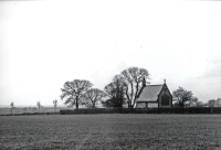
St. Agatha’s Church from Barrow Leas field
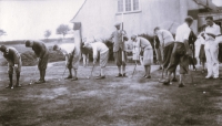
North Downs Golf Club 1927, junior putting competition
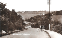
Station Hill 1913


